Urban nature and municipal planning come with their own vocabulary. This glossary translates the most common terms into plain English so that residents, advocates, and anyone attending a public meeting can follow the conversation without a planning degree.
A through C
Adaptive reuse. Converting an existing building or structure to a new purpose rather than demolishing it. An old rail corridor turned into a walking trail is adaptive reuse, as is a former warehouse converted into a community market.
Biodiversity. The variety of living things in a given area. In urban settings, this refers to the range of plant and animal species in parks, gardens, street plantings, and natural areas. Higher biodiversity generally indicates a healthier ecosystem.
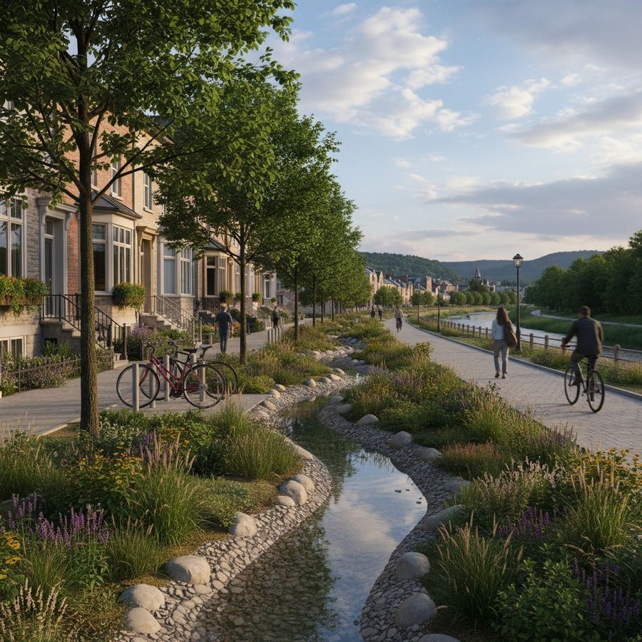
Bioswale. A shallow, planted channel designed to capture and filter stormwater runoff. Instead of sending rainwater directly into storm drains, a bioswale slows the water, lets sediment settle, and allows plants and soil to absorb pollutants. They often appear as planted dips along parking lots or road edges.
Buffer zone. A strip of land between a developed area and a natural feature like a river or wetland. Buffers protect the natural feature from runoff, noise, and light. In municipal plans, buffer zones are measured in meters from the feature's edge.
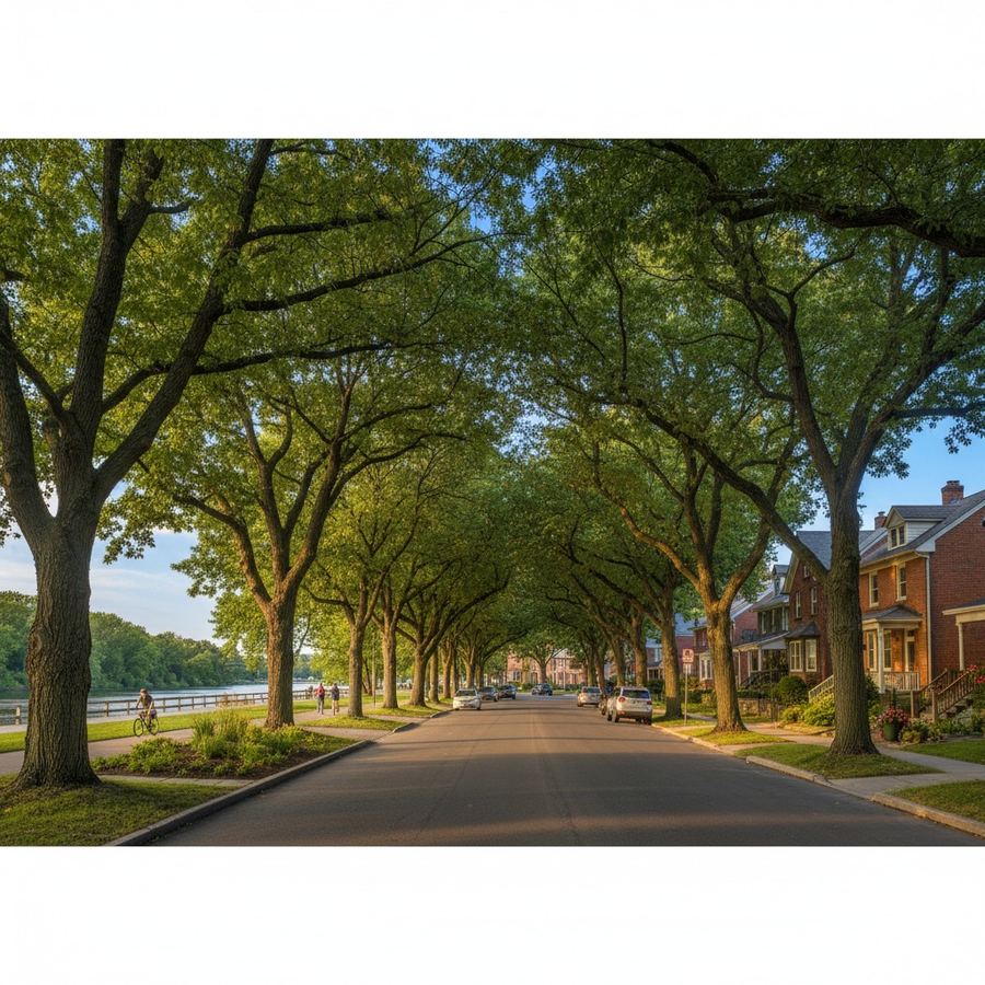
Canopy cover. The percentage of ground area shaded by tree crowns when viewed from above. A neighborhood with 40 percent canopy cover has very different summer temperatures and character than one with 10 percent. Municipal tree strategies often set canopy cover targets.
Complete streets. A street design approach that considers all users, not just drivers. A complete street might include bike lanes, wider sidewalks, street trees, and transit stops alongside vehicle lanes.
Conservation authority. In Ontario, a regional body responsible for managing natural hazards, protecting water resources, and conserving natural areas within a watershed. Conservation authorities regulate development near rivers, wetlands, and floodplains.
Corridor (ecological). A strip of habitat connecting two larger natural areas, allowing wildlife to move between them. In cities, corridors are often river valleys, rail trails, or connected parklands.
D through G
Dark sky. Efforts to reduce light pollution so the night sky remains visible and nocturnal ecosystems are not disrupted. Dark sky principles call for shielded, downward-facing lighting. Some communities have adopted dark sky ordinances. See our article on why darker nights matter.
Daylighting (stream). Uncovering a stream or creek that was buried underground in a pipe or culvert. Many urban streams were buried decades ago for development. Daylighting restores the stream to an open channel, improving water quality and creating habitat.
Ecosystem services. The benefits natural systems provide to people: clean air from trees, flood control from wetlands, pollination from insects, cooling from shade. The term makes the case that nature has measurable economic value, not just aesthetic appeal.
Floodplain. The flat area adjacent to a river or stream that is naturally subject to flooding. Building in a floodplain increases property damage risk and can worsen downstream flooding. Municipal plans typically restrict development in floodplains, though enforcement varies.
Green infrastructure. Systems that use natural processes to manage water, improve air quality, or reduce heat. Rain gardens, green roofs, permeable pavement, street trees, and constructed wetlands are examples. Often contrasted with grey infrastructure: pipes, drains, and concrete channels.
Greenway. A linear corridor of green space, often following a river or rail line, that provides a connected route for walking, cycling, or wildlife movement. Greenways emphasize landscape and ecological function, not just the path surface.
H through L
Habitat fragmentation. The breaking up of continuous natural habitat into smaller, isolated patches. Roads, buildings, parking lots, and fences all contribute to fragmentation. Fragmented habitat supports fewer species and makes it harder for wildlife to find food, mates, and shelter.
Heat island (urban). The phenomenon where urban areas are significantly warmer than surrounding rural land due to pavement, buildings, and other heat-absorbing surfaces. Trees, green roofs, and reflective surfaces help reduce the effect.
Impervious surface. Any surface water cannot pass through: asphalt, concrete, rooftops. The percentage of impervious surface affects how much rainwater runs off into storm drains rather than soaking into the ground. High impervious coverage means more flooding and less groundwater recharge.
Infill development. Building on vacant or underused land within an already developed area, rather than expanding into undeveloped land on the edge of town. Infill development can increase density and reduce sprawl, but the quality of what gets built matters: good infill adds housing and services without eliminating existing green space.
Low-impact development (LID). A development approach that uses natural systems to manage stormwater close to where it falls. Rain gardens, permeable pavement, and green roofs are LID techniques. The goal is to mimic the natural water cycle even in developed areas.
M through P
Mixed-use. A zoning designation allowing multiple uses (residential, commercial, office) in the same building or area. A building with shops on the ground floor and apartments above is mixed-use. Understanding how to read waterfront plans helps clarify what mixed-use means in specific proposals.
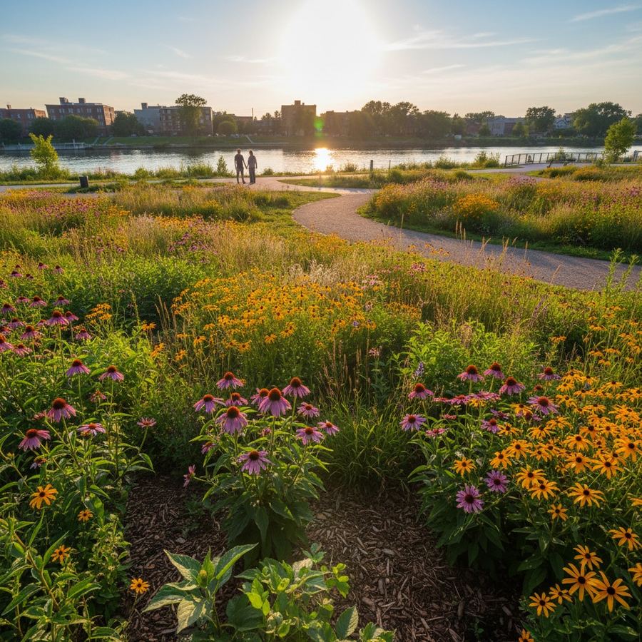
Native species. Plants or animals that occur naturally in a given region, as opposed to species introduced by human activity. Native species are better adapted to local conditions, require less maintenance, and provide more value to local wildlife.
Naturalization. Converting a manicured landscape, such as a mown lawn, into a more natural condition with native plants and reduced mowing. Naturalized areas support pollinators and reduce maintenance costs, though they can look untidy to people accustomed to conventional landscaping.
Permeable pavement. Paving materials designed to allow water to pass through the surface and soak into the ground below. Permeable concrete, porous asphalt, and interlocking pavers with gaps filled with gravel are common types. Used in parking lots, driveways, and walkways, permeable pavement reduces stormwater runoff.
Pollinator habitat. Areas planted to support bees, butterflies, and other pollinators, typically featuring native wildflowers and shrubs that provide nectar and nesting sites. Even small urban patches can contribute if the right species are present.
R through T
Resilience (climate). The ability of a community to withstand, adapt to, and recover from climate impacts: extreme heat, flooding, drought, and severe storms. Resilience strategies often involve green infrastructure, updated building codes, and investments in tree canopy.
Riparian zone. The area of vegetation along the banks of a river, stream, or lake. Riparian zones filter pollutants, stabilize banks, provide wildlife habitat, and moderate water temperature. Protecting riparian zones is one of the most effective things a municipality can do for water quality and aquatic health.
Setback. The required distance between a building and a property line, road, or natural feature. In environmental terms, setbacks from water features protect shorelines and riparian areas from development. A 30-meter setback from a river means no building can be constructed within 30 meters of the riverbank.
Stormwater management. The systems used to handle rainwater and snowmelt in developed areas. Conventional approaches rely on drains and pipes. Modern approaches incorporate green infrastructure to slow, filter, and absorb water before it reaches waterways.
Tree equity. The concept that access to tree canopy should be distributed fairly across all neighborhoods. Lower-income neighborhoods tend to have fewer trees and higher summer temperatures. Tree equity initiatives aim to correct this through targeted planting.
U through W
Urban forest. The total collection of trees in an urban area: street trees, park trees, trees on private property, and trees in natural areas. Managing the urban forest means tracking tree health, planning for replacement, and expanding canopy where it is lacking.
Urban heat. The elevated temperatures experienced in built-up areas compared to surrounding undeveloped land, driven by heat-absorbing materials, reduced vegetation, and waste heat from buildings and vehicles. Urban heat is not just uncomfortable; it is a public health hazard, particularly for elderly residents and outdoor workers.
Watershed. The entire land area that drains into a particular river, lake, or other body of water. Everything within a watershed affects the water body at its base. Watershed-based planning considers the whole drainage area rather than treating each municipality in isolation.
Wetland. An area where the land is saturated with water, permanently or seasonally: marshes, swamps, bogs, and fens. Wetlands provide flood control, water filtration, carbon storage, and habitat. Despite their value, they have been extensively drained and filled for development.
Using This Glossary
This list covers the terms most likely to appear in municipal planning documents and public meeting presentations. If you encounter a term not listed here and cannot find a clear definition, that is worth noting. Planning language that cannot be explained in plain English should be questioned.
For context on how many of these terms apply in practice, the articles on community groups and public space and evaluating trail systems use several of these concepts in real-world settings.